Wednesday, January 25, 2012

Matka canyon - Blue bridge to the Millenium cross on Vodno mountain

  The Millenium cross on the highest point of Vodno mountain is a fixture here in Skope, it's ever presence guarding the city day and night, you can't miss it because it is the biggest cross in the world (66 meters).
  It was built to commemorate 2000 years of Christianity in Macedonia and the world.          The place where it stands is known as Krstovar (place of the cross) since Ottoman times, and there has been a cross there ever since. 
 An interesting fact is that it was financed by the Macedonian Orthodox Church , the government and donations from the Macedonian diaspora.
  The first time I visited it was on my first visit to Macedonia, it wasn't open to the public nor completely finished, but the peculiar circumstances of my coming to Macedonia gave me a chance to visit the site.
  You have an amazing view in all directions from up there, not to mention peace and fresh air. 

Millenium Cross
  Since then, a mountain refuge was built, Dare Djambas ( tel.+38923164365, 25 beds ), run by the Bistra mountaineering club of Skopje, and in 2011 a cableway from the cross to Sredno Vodno (middle Vodno) started operating. The ride lasts about 6 minutes and is 1,6 km long. Very interesting.

Dare Djambas mountain refuge
Cable cars
  Check out www.jsp.com.mk for the timetables. It costs 100 denars round trip, and there is a bus service from the main bus station in Skope to Sredno Vodno, the line is called  Милениумски крст (Millenium cross).
  On my first visit to the cross, I noticed that the surroundings were beautiful, and I started to formulate a plan to come back and visit the area.
  So I did, I came back. 
  Now, I didn't want to go up to the cross just like that, no no.  Had to earn the visit.
What better way then going from Matka canyon to the cross on foot?
  Before we get into the details, you have to decide if you are going to do it from Vodno or from Matka.
  There is a difference of course. If you decide on doing it from Vodno, it is more or less downhill all the way, starting at  an altitude of 1066 meters and finishing at 293 meters.
 Now, for that I'm old school, I prefer to do the hard work first and relax after, so I started at Matka. Also, at the end you get the added treat of taking the cable car down to Sredno Vodno, with an incredible view as a bonus.
  The starting point is the blue bridge at Matka. I got there with the good old number 60 bus from Deksion.

The blue bridge

The Treska river
  Now, this time you have to turn left at the end of the bridge and follow the trail that goes along the right bank of the Treska for about 400 meters.
  Then you will get to an intersection. On the right, going up, is your trail to the cross and from here, you start climbing.

The intersection, you arrive from the trail on the right, turn and go up
  You will see some red and yellow markings along the trail, sometimes they are quite  hard to find, so when you are not too sure, I suggest that you just look to see where the ground has been trampled by other people (or animals!)

Trail going up

and up...

  The route is beautiful and varied, you get some great views of Matka canyon. And just the wind and nature around you.
  At one point, you will get to a clearing, and here you will find a secondary trail on the right going downhill that will lead you to Sv. Nikola , it's fairly easy. It ends up on the main trail from the bridge to the monastery, near the water spring. Then you are 200 meters from the entrance.

  Just in case you change your mind and don't want to climb any more.

The path to Vodno is straight on - the path going down at the right, between the rock and the snow patch,  goes to Sv. Nikola
Another picture of the path going down 
  Just keep on following the initial trail, it will start going up again, and you will soon arrive at a water spring in the middle of nowhere. You can drink the water by the way, that is if you are a water drinker. I tried the stuff, got no taste, I prefer wine, period. 

The path to Vodno after the intersection
Water spring
  You get some nice views of Sv. Nikola along the way, I  also took a couple of pictures of  Sv. Nedela on the other side of the canyon. Very nice. It gives you an idea of the trek down to Sv. Andrea. 
  Looks pretty vertical, huh? it is. But it's a rip!

Sv. Nedela and the hut to the right. In orange is the way down to Sv. Andrea. You can also see the trail from Sv. Spas on the right.
   After the spring, I started finding more snow as the altitude increased. Also found some ice in some parts, which makes going up easier then down in these conditions.
Another reason I chose to start the trail from Matka.

Snow
and more snow...
  Eventually, you arrive at another clearing, larger then the first one, with some of the best views of the canyon. When I was there, it started to snow, but  the sun was still shining in the west. 


   From there, you aren't too far from the top of the canyon. It's a good climb, it's about four kilometers from the bridge to the top and beautiful all the way.
 Once there(alt. 880m), things start easing up a bit, it gets flatter and you can see the Millenium Cross in the distance. 

At the top of the canyon
The Millenium Cross in the distance
  You have about eight more kilometers to go.
  This is where the cowboy in me starts coming out,  you're in the middle of nowhere, and all you have are cows scattered all around the place. 
  I call this part the "Cow Cow Boogie" trail.
  So I start singing the song.

The"l'il dogies", minding their own business


  The song has nothing to do with Macedonia, so I do apologize for this little twist to the blog, but the song seems to be appropriate for the trail. And the "l'il dogies" (cows).

  Anyway, after a while we get out of the far west, and we continue our trek on to the cross. The trail and the red markings can be hard to find sometimes as mentioned previously, but common sense will get you where you are going.

The red and yellow markings
  The scenery changes several times, you go through some nice  woods, then rocky terrain, and so forth.
 I must point out that the route that I am describing in this entry is what could be called the "official" route. I am not quite sure who traced it, but it works out fine.
  If it's your first time doing this trail, it is best to follow it. However after getting well acquainted with it, you may wish to use a slightly different route on some parts, as you will notice that if you methodically  follow it, you will miss out on some nice ridges and spectacular views. I suppose the trail was created for working purposes . People who live and work in the mountains will always privilege practical  rather than spectacular. But always know where the official route is, it is your guideline. It can be easy to lose yourself in certain conditions. On the day I did this route, a couple of people got lost on Vodno mountain and had to be rescued by the police and the Red Cross mountain rescue team, they were freezing. And believe it or not, they were real close to the Millenium Cross and apparently, me. It is easy to get disoriented, so be careful.
  Just another reminder to emphasize safety; the mountain is unforgiving in the winter, so if you decide to go there, be properly equipped, chose the appropriate clothing, make sure you tell your friends or family where you are going and have cell phones that work. Be safe, not sorry.
  
  There are several huts along the way, the nearer you get to the cross. The first one has a great view of Skopje.  And you can see the cross, not too far to go.

The first hut, with a great view of Skopje, at least on a good day!
From the hut, you can see the cross in the distance
The trail continues, in and out of woods
   The closer you get to the Millenium Cross, the larger the trails. You pass a few more huts and a refuge, and you also walk through a beautiful Birch tree forest at one point. Not too many of those around Skopje.

Refuge
The view to the south west
   After a few hours of trekking, you arrive at the highest point of Vodno mountain, the Millenium Cross. 
  It is hard to tell how long the whole trip takes, It can be done in around 4 hours without any significant problems for most people, but it depends if you stop a lot, like I do, to explore other parts, if you have lunch, if you want to go fast or slow, etc...On this occasion, I was slowed down by some icy parts and the snow didn't help, but that is part of the fun. I don't consider this kind of activity as a race, there is too much too see and explore. And one of my biggest  pleasures is eating and cooking outdoors, so I always take some time for that.


   It is now time to go down to Sredno Vodno with the cable car.  Or you can spend the night in Dare Djambas. Whatever you decide, Vodno mountain is a great place to spend some time away from the city. It is remarkable how fast you go from a city environment to a mountain one. 


  I have the GPS course, so you can visualize the trail in better detail, and if you have a GPS, you can download the route and not have to worry about losing track of the trail.  
Just contact me (through the comments link at the bottom of the post) and I will be happy to send you the links and information.
   I will do an update on this route at an ulterior date, when the weather will be better, around spring time, because not everyone enjoys the snow and winter conditions like I do, and spring up there is something else. 
  Winter does have it's benefits, for example you get to see all the wildlife tracks in the snow, such as rabbits and boar. Of course, you get the occasional dog tracks, this IS the Balkans! And you get to avoid the sweltering heat of certain summer days. You have all the snow you want to do the dishes, and apart from a few "L'il dogies", you wont see many people along the way. It does get much busier in the more clement months of the year.

  There is something for everybody up there, so enjoy yourselves!


Saturday, January 14, 2012

Dimitar Bocevski, my friend from the mountain


  We all  have friends and acquaintances in our lives, people that we know more or less, good friends and some less good. Such is life and human nature.
  Sometimes our friends date back to primary school, some are more recent. And for reasons unknown, some are for life.
  And there is this special type of  person, the one that you don't know so well, but you feel good in their presence, you have the same interests, the same passions, and you want to see more and more of this person, there is some connection that you can't describe, but it exists, it is there.
  Dimitar was just such a person. Felt good with him, we had some great times together and had some plans to check out some climbing spots. We even shared an interest in knives. Damn, that was pretty cool.
  We also had the same vocation  for helping others in the time of need, he was part of the Red Cross mountain rescue team. People who do this kind of work share a special bond, and I had it with him.
  We talked about a whole bunch of subjects, and it was always interesting.
  When I went to Sv. Nedela the other day, it was my first time there, and I cannot begin to tell you how much I enjoyed myself and how beautiful it is.
  I spent some time there thinking about Dimitar.


Up there, I found what I was looking for
I hope you did too


Never forgotten, my friend

Matka Canyon-the road from Sv. Bogorodica to Sv. Nedela

  In the further adventures of Matka Canyon, we shall explore another beautiful part of this country.
  This route takes us from Sv. Bogorodica, near the blue bridge on the Treska river, to Sv. Spas, then Sv. Nedela and finally, as an option, Sv. Andrea.
  This was a trial run of the route as the first part of the trail  is not well defined, as it turned out the route I took can be improved on, so I will post a correct one later, after a secondary and well planned trek there. But if you follow the red marks as I and undoubtedly most people do, you will end up off course and with no more marks to follow. I did meet a young dude who was herding cows, but the route he suggested to me went through "Gorna Matka" village (upper Matka), and of course this route does take you eventually to Sv. Spas, but on a large dirt road that, in my humble opinion, is not interesting nor particularly scenic. More fun is to be had going through the hills, which is what I did, and I got to Sv. Spas about an hour later.
  The beginning of the trail starts near the monastery of Sv. Bogorodica (Holy Mother of God), altitude 305m, on the left bank of the River Treska. There is an inscription  above the entrance, dated 1497, and we learn of one Milica who, finding the church roofless, recovered it, frescoed it, erected a portico and bought a vineyard for the monastery.                  
  The dudes in those days had their priorities right.

  The church has the form of a narrow inscribed cross.  The frescoes date from the end of the fifteenth century and have all the characteristics of painting during the Turkish period and represent a considerable falling off in comparison with Sv. Andrea. In the floor level zone of the west wall are portraits of the patrons Milica and Nikola. Some repairs were carried out at the end of the nineteenth century.

The road to Sv. Bogorodica. Notice the blue bridge  on the left.
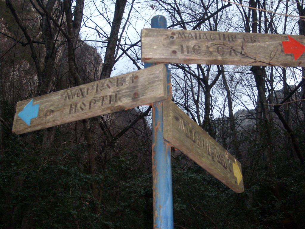
Follow the signs
Sv. Bogorodica
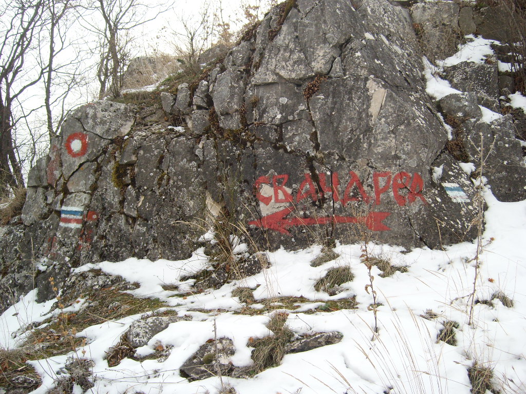
  From this point, you are supposed to follow the red marks. Which I did. Good boy. But as mentioned previously, after a while you lose sight of these marks, so I improvised. The idea is to get to Sv. Spas, and this should take about an hour or so. 
  This little church is located on very scenic vantage point, the view is fantastic to say the least, and the surroundings are pretty and peaceful. There are tables and shade, trees and water, and just before you get there, you will see some large limestone blocks of an ancient fortress, which was populated into Ottoman times. It was then part of Markov Grad (Marko's city) and history has it that it was a hideout for Macedonian revolutionaries , until the Ottomans found out and destroyed it.

  But there is another, more romantic version to the end .

  An Ottoman bey fell in love with the beautiful Bojana of Marko's city, but when she refused his overtures, the bey decided to take her against her will. However, Bojana fought back, and the inhabitants of the fortress defended her by killing almost a hundred Turk soldiers.
  It was then that Bojana realized her fate was sealed and threw herself to her death off the steep cliffs down into the river Treska below.
  The soldiers took their revenge by razing the fortress to the ground, and the only building still left partially standing is Sv. Nedela, with it's ruined archway and stone walls.

  Don't know about you, but I prefer this ending.

  The monastery dates back to the 14th century, and was built on the ruins of an earlier church. It is small, but it and the site is well maintained. It was renovated in 1968, and currently some more renovation is in process. Altitude 640m.

Sv. Spas
Sv. Spas
Part of the site
  Great place to relax and breath some fresh air, but trust me, the best is yet to come !

  From here, you can see your next destination on the other side of the canyon , Sv. Nedela   ( 750m), and when you look at it, you start thinking  how on earth am I going to get my righteous butt up there! it seems almost unattainable, perched high up on vertical cliffs like that. 
  It makes you wonder how they built fortifications and the monastery there over 500 years ago.
  Remarkable.

     Probably the vineyard at Sv. Bogorodica helped a bit.

     Well, the Egyptians had beer, and the Macedonians wine. Respect. 

Sv. Nedela, you can notice the hut
  Fortunately, the trail to Sv. Nedela is self explanatory, there is just one possible route and you can't miss it. But  when you take it, you have no idea how you are going to get to the monastery, but you do eventually, it takes roughly 30 minutes. As you can see, when I did it, everything was covered with snow, which makes things slightly more complicated (I LOVE challenges) but at the same time magical.
  Imagine taking a trail with pristine snow, no one has been on this trek, you are the first...makes you feel like a polar explorer!
  I must emphasize the fact that this trail can be difficult at some points, you have to be careful, and it is possible that people who suffer from vertigo may wish to refrain from taking this trail, especially as things get a bit more complicated and hairy at the monastery. I always advocate safety first, so it is up to each individual to decide if this trail is for them or not.
  A reminder; Matka rescue team; 071 261 013
  Along the trail are a couple of benches and a spring. In the summer, it must be wonderful to chill out there. 


      Then the trail starts going up and you end up at the beginning of the monastery.


Just after entering the fortification 
  You have to climb a bit to enter the site, you pass some remnants of an old fortification (Marko's city) and then you can start exploring, you have the archway in front of you, behind it is what remains of the monastery. There is no roof, just some walls,  but you can still burn some candles and get mystical if you so wish, and looking hard enough, some old frescoes are still visible.

The interior of Sv. Nedela

Ruins next to the monastery
ruins
  The site was very well chosen, as there is only one way to get there, water nearby and the best view possible. 
  A few meters below is a modern hut, this is where I wanted to have my lunch, but on that day, the wind and the cold forced me to more clement surroundings.

Recent hut

 I do not know why, but the sign at the entrance of the hut is translated in French. 
     I presume it was built with the help of French (speaking) Volunteers. Sacré bleu! 

 View towards Skopje

 View of the snow covered mountains
  In such a beautiful place, it is not difficult to find a nice spot (with a view of course) to have lunch, so I found one and proceeded to cook myself some Korean ramen and some Macedonian smoked sausage with onions, accompanied by some delicious Mastika from Strumica (www.grozd.mk). Wine would of been nice, but  I find that frozen, it is not palatable.


In front, you can see Sv. Nikola
  Since all good things must come to an end, I washed the dishes and then had to decide how I was going to go back down. I had two options, go back the same way I came, or try the trail that goes down to Sv. Andrea (alt. 340m).
  Now, this trail is very steep. I would not recommend it for most people, but as mentioned previously, everyone should know their limitations and, If you are not sure, don't take it, better to be safe than sorry.

The sign points out the beginning of the trail.
  I studied the topography and explored the area.    
  After some serious cogitation, I went hardcore and decided to give it a try, I could always turn back.
  It is indeed very steep, and probably easier to go up than down. But if you decide to go up this trail, you better be fit because it sure ain't easy. Also, it should be avoided in case of muddy conditions, as it would be dangerous and  too difficult to do.

The way down to Sv. Andrea. Hardcore vertical 

  I started trekking down, looking for signs of a trail, but nothing, no red markings either. So, I just used my experience to figure out the route and after a while, I found it and just  followed it and the markings down until I eventually arrived at the Matka climber's club site, next to the Treska lake (www.matkaclimbing.org)

some directions at the bottom of the trail
  It was one hell of a trek down, the muscles in my legs were hot, but it was a rip!
Fell on my ass a couple of times, even tore a whole in my pants, but hey, that's what I call fun LOL. 

  Sv. Andrea was erected in 1389 by Andrea, the son of King Vukasin, and brother of King MarkoIn the 16th century, a narthex was added to the church.  The frescoes in this monastery are different from the traditional styles of the middle ages where the figures are more realistically painted. The majority were created by Jovan the Metropolitan (very groovy name). Considering it's age, it is in great shape.

Sv. Andrea
  Of course, there was another factor in my decision to take this trail down to the monastery.

  It is adjacent to the Canyon Matka restaurant (www.canyonmatka.mk) where a poor, tired and cold hiker (such as myself) can find a nice table and song.
And a  little something to warm my spirits up.


  So after a little something (some fine wine of course, maybe from the old vineyard at Sv. Bogorodica), it was time to start moving again.
  The walk along the lake is absolutely magical at night, it is well illuminated and just 20 minutes to the bus stop.

  And then civilization.

  I will post a GPS map of this route soon, I just have to go back there and trace out a new route to Sv. Spas, weather permitting. 

 It is a fantastic hike, I had a really great time. Felt like I was in the middle of the Himalayas.

  But Matka has a way of doing that to you.